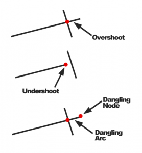
Topology in GIS refers to the relationships between objects that are connected. The concept most often appears in the context of topological errors related to vector objects. The basic errors include:
- Overshoot (przeciągnięcie), and
- Undershoot
Correct spatial data is free of topological errors. These errors can cause algorithms, such as shortest path searches, to function incorrectly. A tool that helps edit data without topological errors is Snapping.
Comparison
Network topology is equally critical, for example, in data used for car navigation. It is easy to imagine that an undershot road at an intersection will cause a detour to be calculated because the algorithm assumes there is no proper connection.