Dozens of projects. Hundreds of plots. Dozens of files per project.
And everyone on the team has their own version.
Usemaps organizes all portfolio data in one place - every plot, every status, every change visible to everyone. From location analysis to farm management.


Challenges of renewable energy projects
Renewable energy projects are complex by nature. Managing them doesn’t have to be.
Each project involves dozens of plots, a dozen or more stakeholders, and years of the investment process. We’ve gathered the challenges most commonly mentioned by project managers and executives in development companies.
Good locations disappear before you have a chance to analyze them
In renewable energy, location windows close within weeks. If analyzing plots, protection zones, and land ownership takes several days, someone else may sign the lease agreement first.
A portfolio at ten stages simultaneously. One view of the whole? It doesn’t exist.
One project is in the location phase, another is waiting for a zoning decision, and a third already has a building permit. Management asks for the status of the entire portfolio - and you have to call three different people to piece together an answer.
Due diligence is a race against time. Documentation is scattered across the entire company.
The bank or investor is waiting for the full project documentation. Gathering it from emails, drives, and folders across four departments takes a week. Every day of delay carries a cost - both financial and reputational.
Lawyers, surveyors, and municipalities - each wants different files in a different format.
A renewable energy project involves dozens of external parties. Each requires access to data - but under different rules. Instead of controlled sharing, you send files by email and lose control over who receives what.
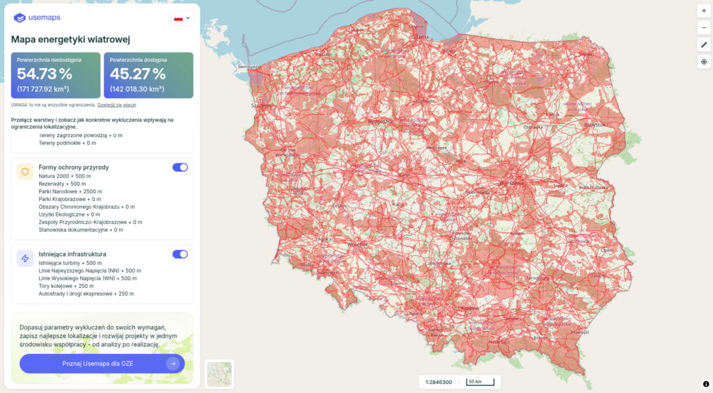
Zones and regulations change. Your analyses - may no longer be up to date.
The local zoning plan has changed. The protection zone for the military airport has been updated. A location analysis from six months ago may now be outdated - but no one has time to verify it for every project.
Project knowledge leaves the company along with the people.
Why was this location dropped from the portfolio two years ago? Who did we talk to at the municipal office? What were the agreements with the landowner? If this knowledge exists only in people’s heads and emails, every staff change means starting from scratch.
Why Usemaps?
This is what a renewable energy project looks like when you use Usemaps
Three areas where Usemaps transforms the daily work of development teams - from the initial location analysis to financing closure.
Analysis of a new location in minutes, not days.
- Ready-to-use data layers updated automatically - airspace zones, boundaries, and land ownership.
- Distance and buffer analysis without GIS expertise
- Anyone on the team can independently assess the potential of a plot
- The history of analyses is saved for each location - you know what was checked and when
A single view of the entire portfolio. From location to an operational farm.
- A portfolio dashboard with a view of all project stages at once
- The full project history - decisions, agreements, and location changes with dates
- A new team member sees the project context from day one
- A status report for management with a single click - no preparation needed
Due diligence ready in an hour. External partners with controlled access
- All project documents in one place, linked to the specific plot or project stage
- External sharing with control - lawyers see only what they are supposed to see
- Export project documentation with a single click - ready for due diligence
- Full access log - you know who viewed project data and when.
Challenges we solve
Teams working in silos
- Everyone works on their own copy of data
- Poor communication leads to duplicated work, version conflicts, and project errors
Seamless data flow
- Centralized data access management
- Maps, documents, and analyses - always current and accessible. GIS, Excel, and documents integrated into one platform.
Time-consuming analyses
- Each location analysis requires days of manual processing
- Checking zones and buffer distances - repeating from scratch each time
Efficient tools
- Automated intelligent workflows
- Predefined algorithms instantly analyze buffer zones and conflicts to identify optimal locations
Data everywhere, control nowhere
- Maps in PDFs, analyses in Excel, documents in emails
- Time wasted searching for information with no synchronization
Complete knowledge access
- Real-time collaboration
- Everyone sees the same data, adds comments, and assigns tasks. Change history and full transparency in project management.
Wind Energy Map
It works very well on mobile devices and is useful for field work.
Basic functionalities
- Switching Constraint Layers
- Additional layers (wind turbine location)
- Navigation to the selected point
Success story
How Infranika Energy Partners built a record-breaking renewable energy portfolio with Usemaps
Infranika Energy Partners developed a project portfolio totaling 2.2 GW of large-scale energy storage and 230 MW of wind capacity using only a small team with Usemaps as their central management platform.
With Usemaps as our single source of truth, we eliminated time wasted transferring projects between teams – reducing documentation and handover time by 85%. The integrated communication platform eliminated duplicate location analyses, cutting analysis time from weeks to days or even hours.
The mobile application enabled real-time field coordination, eliminating office visits. Usemaps’ advanced analytical tools, combined with our proprietary data, enabled comprehensive spatial analyses in real time. The result: fundamentally accelerated project development and significant competitive advantage on every project.
See how Usemaps will accelerate your business
Industry specialisations
Each energy source has unique requirements. Our solutions are tailored to each technology
Wind energy
Specialized features
- Global Wind Atlas integration
- Instant exclusion zone mapping (distance regulations)
- Access to all essential spatial data (cadastral parcels, classification contours, land ownership)
- Automated rotor sweep zone and foundation area calculations
- Agricultural infrastructure conflict analysis
- Automatic recalculation when locations change
Solar energy
Specialized features
- Automated usable area calculations
- Soil class and organic soil detection
- Slope analysis and modeling
- 65% faster profitability decisions
- 3.25× faster site analysis
We have answers to every question
We currently use QGIS. Can data from QGIS be transferred to Usemaps?
Yes. No problem. All data can be imported into Usemaps. Then it can be used in the browser environment, through the QGIS plugin, and in the mobile app.
Can we install Usemaps in our IT infrastructure?
Yes. Usemaps can be deployed on-premises at your company, on our servers, or in any data center – including AWS, Azure, or other cloud platforms.