

 0
 0
 0
 18 November 2026
Working with people in the field requires easy access to information and efficient data transfer to the office-based team. For landhunters, it is important not only to check a land parcel on the map, but also to record information collected during site visits and use it at subsequent stages of site assessment.
During the webinar “Collaboration with Landhunters and Site Assessment – Practical Insights from Usemaps”, we showed how this process can work with the mobile solution currently being developed in Usemaps. We focused primarily on access to field data, geonotes, sharing information with the team, and further analysis of the reported location.
Usemaps in the Field – Simple and No Additional Installation Required
One of the main principles of the mobile solution is to reduce the number of actions required from users working in the field. They do not always need the advanced features typically associated with GIS systems. What matters most is quick access to preconfigured data and the ability to perform basic tasks without additional setup.
The solution works directly in a web browser. Users can open the same Usemaps address they use on a computer, log in, and access a view adapted to mobile devices. There is no need to install a separate application. GPS positioning is also available, and after selecting a location, users can go directly to navigation in Google Maps.
Geonote – A Quick Way to Record Field Information
One of the main ways of sharing information during fieldwork is through geonotes. Users can add a pin at a selected location and provide a short description, without directly editing the reference data used within the organization.
The information can be entered manually or added using the phone’s voice dictation feature. The spoken message is then converted into text, making it easier to record information in situations where typing on a keyboard is inconvenient. Once saved, the geonote automatically appears in the main Usemaps interface without the need for a manual refresh. The pin is added as an object on a layer and becomes immediately available to users working in the system. The process can also be supported by an email notification informing the team that new field information has been added.
From Field Information to Site Assessment
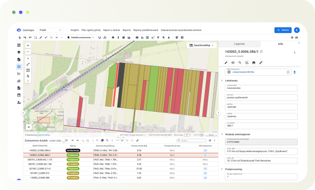
The location reported from the field can then be further analyzed in Usemaps. For a selected land parcel, data can be retrieved from ULDK and selected parameters used in site assessment can be calculated automatically.
In the example presented during the webinar, the system automatically calculated the parcel area, the distance to the nearest Main Supply Point (GPZ), and the distance to the nearest national park. The scope of these calculations can also include additional criteria, such as protected areas or parcel shape. It is also possible to use formulas to score sites based on selected parameters.
Offline Work and Further Development of the Mobile Solution
For fieldwork, access to data is also important in areas where internet connectivity is limited. Data for a previously opened area can be stored on the device and remain available after the connection is lost. A geonote created offline is saved on the phone and uploaded once the connection is restored. The option to download a selected area in advance is also being developed.
Another direction of development is the integration of the mobile solution with projects managed in Usemaps. Users are expected to be able to select a specific project and display related objects, such as land parcels, planned wind turbines, or cable routes, without having to configure multiple layers manually. Access to the object card is also being developed, including attributes, notes, attachments, relationships, and comments. The main principle, however, remains to keep the solution simple and adapted to the conditions of fieldwork.
Simple Solutions Tailored to Fieldwork
Experience gained from developing mobile solutions shows that the needs of people working with data in the field can differ significantly from those of users who work with GIS systems at a computer on a daily basis. For this reason, the development of Usemaps Mobile focuses on quick access to the necessary information, reducing unnecessary steps, and ensuring efficient data exchange between field users and the office-based team working in Usemaps.
Want to See Usemaps in Action?
If you would like to see how Usemaps can support data and project management in your organization, we invite you to a platform demo.